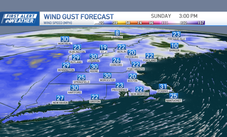
This afternoon, as a cold front moves offshore, we can anticipate improving weather conditions accompanied by a brisk west wind. Cloud cover will be variable, with occasional sunny intervals and the possibility of isolated showers persisting into the evening hours. Expect gusty west winds reaching up to 30mph by early tonight.
Despite the gusty winds, the St. Patrick’s Day Parade in Southie is expected to proceed as scheduled, although there may be a chance of a stray shower or sprinkle during the mid-afternoon period. High temperatures are forecasted to range from the mid to upper 50s in southern areas, while northern regions can expect temperatures in the 40s.


Overnight, expect clearing skies with chilly conditions, although temperatures will remain slightly above average. Lows in the metro area are forecasted to be in the mid-30s, with cooler temperatures expected in northern and western areas, ranging from the upper 20s to low 30s far north. While the gusty west wind is expected to diminish overnight, it is anticipated to pick up again on Monday.
The start of the work week will be predominantly dry, with morning sunshine gradually giving way to a few afternoon clouds. There’s a possibility of a rain/snow shower across western and northern areas. Wind speeds will increase slightly in the afternoon from the west before subsiding in the evening. High temperatures are expected to reach the upper 40s to low 50s in southern areas, while northern regions will see temperatures in the 40s, and 30s across higher terrain.
Tuesday, the first day of Spring, is expected to be slightly cooler with a mix of clouds and sunshine. There remains a possibility of mountain flurries and snow showers. The vernal equinox is set to occur at 11:06pm on Tuesday night.
A fast-moving upper-level system will traverse the region on Wednesday, leading to the development of snow showers in the northern mountains and snow/rain showers in southern areas by late in the day. The remainder of the week is forecasted to remain cool, with the potential for additional unsettled conditions by the weekend.
Wishing everyone a wonderful St. Patrick’s Day!